


It appears that for the August long weekend, most of Calgary headed to Squamish. I can understand why, the coast was having a stretch of excellent weather and a lot of mountain activities were in peak form (see Butt Lite trip report). After a lot of planning, bailing and re-planning, Charlie and I met up with Piotr friday night and decided to head up Sigurd Creek the following morning, just on the north end of the Tantalus Range. Sigurd Creek is mostly maintained by the BCMC, the Vancouver competitor of the ACC. When I say maintained, there are no huts, but there has been an impressive amount of work that has gone, and is currently going, into trails and markings. Trails and access on the coast are a major issue, and without a trail, the area is only accessible by helicopter or a multi-day slog. The ACC has staked its claim to the Lake Lovely Water basin to the south with 2 huts. However, the access is challenging involving trespassing on government property (a Tyrolean) and bribes to safely park ones car near the reserve, or a helicopter. The Sigurd Creek area was a relative joy, with straightforward parking, a well marked trail and legal access to the area.
The trip plan was simple. We would hump our packs the 1750 m up Mount Sigurd on the BCMC trail. The trail disappears at the peak, so we would scramble to Sigurd Lake where we would spend night 1. We would then head over to Mount Ossa, set-up camp near the 3 lakes, climb Mount Ossa and return to camp for night 2. Our last day could have involved an ascent of Mount Pelion, but since Charlie and I had to catch a flight that night, we opted to just head straight out instead of a 3:00 AM start. The route we followed is shown below.
Total climbing: 3444 m
Total descent: -3383 m
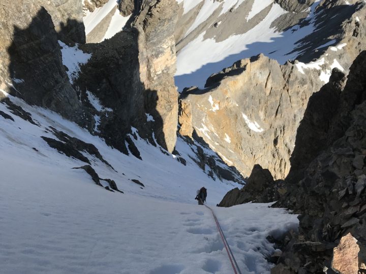
Mount Sigurd is a brutal grind, especially with weekend packs, but is otherwise a straightforward hike with beautiful views. The scramble over the peak to Sigurd Lake involves snow and descending crappy granite kitty litter/talus. The bowl east of the lake is cliffy and must be descended from either the col straight east of the lake or to follow the ridge SE of the lake. The lake still had ice, but that didn’t stop Piotr from taking a swim.
The bushwack from Sigard Lake to the three Ossa Lakes involves negotiating steep vegetation, but there is a beautiful, non frozen lake at the bottom for a swim and to wash the moss out of our pants. Descend the south west side of lake in a south westerly direction. Once at the bottom, we contoured to the marked trail that ascends the west ridge of Mount Ossa. We set-up camp at the bottom of the 3 lakes. Running water is a problem in this area and most campers head to the highest of the 3 lakes as it is in a different drainage with a creek that runs through it.
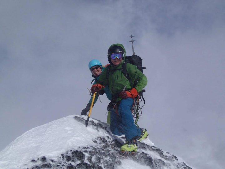
Ossa is a scramble that starts off easy and progressively gets more and more difficult. The summit pinnacle is a difficult scramble (5.0). We brought ropes and harnesses, but opted just to carry them. The views of the Tantalus range are probably beautiful, but it clouded in and we could only see north. We headed back the way we came and went for a refreshing swim back at camp. We had run into 4 VOCers and spend the evening cooking dinner and talking with them.
We woke up relatively late and headed out. It was still a long-way out and we reached the car at 3 pm. Dinner at the Riverside Cafe and a traffic jam on Highway 99 left us with just enough time to make our 9:30 pm flight.
A fun trip, with fun people and a beautiful area. I’d love to head back to climb Mount Pelion, but I might save it for a winter ski ascent. The most interesting way to do it would be to do it on-route of the Tantalus Traverse. However, that seems like a rather committing option.
Pictures below:


0 Comments
Leave a reply
You must be logged in to post a comment.