

Aug 31 – Sept 1 2019

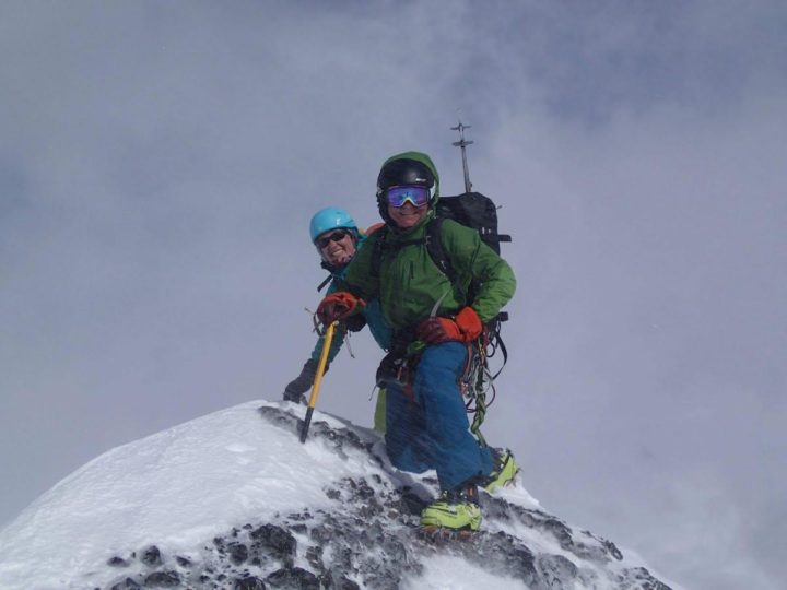
Summit photo thanks to Scott. L-R: Julie, Paula, John, Vi, Laura.
Mt Cline has been on my list ever since I first heard of 11,000ers. The classic route along the southwest ridge is rated as a 5.3 with easy glacier and ridge travel. The 2 notches on the summit ridge sounded super fun and the added bonus was a lakeside bivy site that had rave reviews in all the trip reports.
My daughter Laura and I were looking for a Labour Day weekend objective and Mt Cline seemed like a good choice. She had summited Mt Cline last year in cloud cover and wanted to return for the summit views. My partner John declared he was ‘in’ so we decided to post it as a club trip. Our plan was to hike in on Saturday to camp at the bivy, summit on Sunday and return to our cars that same day. We posted the event as an ACC trip and my good ACC friends Julie Muller and Vi Pickering signed up right away. It looked like it was going to be us girls and John, fortunately 5 days before the trip Scott Miller joined us. Now we were a group of 6. Julie would bring her half rope and John his trad gear. Each of us would take bivy gear, ice axe, crampons, glacier and rock climbing gear.
The week prior to the trip none of the weather forecasts were looking promising. All 7 models of Meteoblue, a very cool integrated forecasting tool, complete with probabilities, was looking pretty blue with rain on both Saturday and Sunday. I kept expecting at any moment someone would pull out. On Friday night I was starting to think I should do everyone a favour and cancel the trip. At 6:00 am Saturday morning when we were getting the cars loaded up, Vi called. She had just looked at the latest forecast for Nordegg; thunderstorms had now entered the forecast for both Saturday and Sunday. We reassessed and decided to ‘give it a go’ and see how far we could get, after all you don’t know unless you go! Within an hour of driving we were in a full-on thunderstorm. With flashes of lightning and pelting rain we pressed on, no ‘turn back’ text messages appeared! As we turned onto the David Thompson highway, the rain began to ‘let up’ and the sky brightened ever so slightly as did our hopes for the trip. By the time we parked the cars at the turn out by Thompson creek, the rain had stopped completely and the sun had appeared. Hurrah! I congratulated the group on making it to the trailhead, overcoming self-doubts about the sanity & sensibility of our trip.
At 11:00 am with packs on, we headed along the path on the right-hand side of the Thompson Creek. Note that the guide book says to stay on the left-hand side, however since the book was written the trail has clearly been developed on the right. At about 1km we came to a creek junction with a beautiful waterfall and deep plunge pool. We easily crossed the intersecting creek on a log bridge. The trail continued back and forth over the main Thompson Creek on log bridges and was well marked with flagging tape. At about 3 – 4 km a large headwall appeared on the left. In the distance was a waterfall, probably Thompson Creek Falls. It was at this point we did a sharp left turn up a gully which wasn’t well marked. Fortunately Laura, who was familiar with the route, directed us up the very steep hard-packed gully which took us to a treed bench. The next section was a long arduous side hill across scree and boulders. Laura again directed us, to stay lower on the slope, follow a line of occasional cairns to reach a treed meadow section that followed the creek. After about 3.5 hours of travel from the parking lot, we came to an ominous-looking band of black rock. From the GPS route on John’s phone, we knew we had to go up the band. We scanned the top and bottom for cairns, Julie saw a ‘weakness’ in the rock on the far climbers’ left with a snow patch above. The rock was loose and sketchy but fortunately, the section we had to scramble up was short. Once we made it to the top half of the band we used the snow patch which made it a lot easier.
The last km was easy travel to reach the lower of the Cline Lakes, an ideal spot for a bivy site. As we walked along the shoreline we admired the beautiful sedge like grasses, gravel beaches and mudflats. The water was crystal clear and the reflection of the 10 foot high, tilted rock beds on the west side was stunning. At the North end of the lake, we found a relatively flat, pebbled area to pitch our tents. The site was as promised, a beautiful alpine landscape at which to spend an evening admiring the peaks, listening to the babbling brook and sharing a backcountry meal with friends. For me it was especially special to share with my daughter.

Scott sets up his tent by the lake.
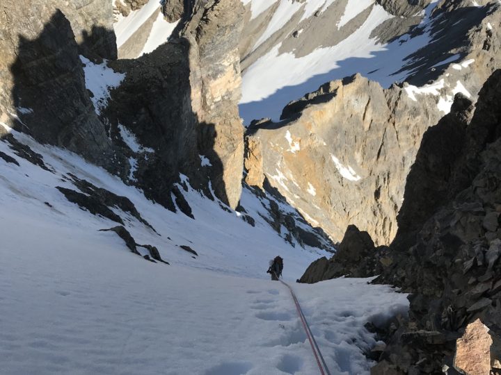
We went to bed that night fully anticipating the rain would come, but it never did. We woke up at 4:00am to a star filled night and headed out shortly after 5 o’clock. Soon we reached the far end of the second lake and at that point a well-defined, steep ramp headed left and led to the top of a headwall. From here we began a long steady uphill hike, traversing right. As it was still quite dark, John was able to guide us using the gpx. track on his phone. Good thing as we could have been wandering for a long time. At about 6:30 we were glad to reach the toe of the snowfield, sun was up but unfortunately we were also at the cloud ceiling. No sign of Mt Cline yet. Would Laura be skunked a second time?!
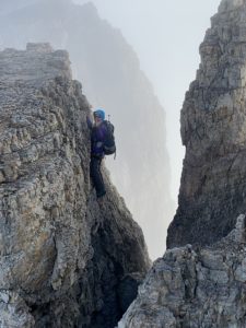
We initially put on our crampons but shortly took them off as we came to a rock field. The snow did reappear but we decided not to put our crampons on as the snow was relatively soft and the slope low angle with no sign of glacier ice or crevasses. Within half an hour we had reached what Bill Corbett calls the col. It was at that moment the clouds lifted, everyone immediately took out their cameras and Julie filled the mountain air with happy yips of joy. We were cautiously optimistic that a panoramic view awaited us. As we looked north along the ridge, we saw a 15 foot wide, 30 foot high U shaped opening in the ridge. With the sun shining brightly through the clouds on the east side, the opening looked like a doorway leading to a magical alpine world, where the notches awaited us.
We easily accessed the ridge, and after a short scramble, there ahead of us was the opening of the first notch. While we had all seen photos of the notches, it is always exciting when you see a dramatic photo come alive. In fact, the opening looked more like a crevasse in the rock, but without the snow bridges! We would have to first climb down 15 – 20 feet, cross to the other side around a rock island tower and then climb out the other side. Perfect photo opportunity! But how to protect it? While John & Laura conferred on protection, Julie got so excited she decided to traverse the notch solo! Off she went, making a perfect silhouette of a climber on a rock face with the backdrop of mist-like clouds which enveloped the summit peak of Mt Cline. As for the rest of us, we were happy to use the rope. John was belayed by Laura down to the rock island, crossed a gap on a chockstone and then climbed up a relatively easy wall navigating the loose rock, testing each of the holds as he went. When he reached the other side, he found a piton and was able to set up a belay. We now had Laura belaying each of us on the downclimb and as we got to the middle, the belay would switch to John on the up. Pretty cool, our first notch puzzle solved.
Julie has fun climbing solo.
Within 50 feet the second notch appeared, and we soon realized that this rock crevasse would be a different story. We knew from the description that we would have an airy step across the gap between the two walls, the question was just how big was the step? There was a bolted anchor at the edge we were on and as we looked down we could see that the rap was slightly overhanging, oh joy. We would need to rappel down into the void and then swing over to the other side, to climb up what looked like a short but rather intimidating climb on loose rock. While it was clear what we had to do to now, it wasn’t clear how we would get back.
John committed as the lead, in true Indiana Jones style, making the plan up as he rapped into the gap. We all breathed a sigh of relief when he reappeared on the far side, took himself off the rope and easily climbed back up to the ridge. What was his plan for the return? On looking back to the overhang, he was definitely delighted to discover an easier route to on climbers left for the return trip. It would be a big step across but doable. When it came to the last person, luckily John had a plan and we did not pull the rope. He instructed Laura to leave the rope slung in the anchor on the far side and bring the ends of the rope up with her. By having the rope slung in the anchor on the far side, this would mean that the lead would be on belay when stepping across the void. Good plan! With Notch number 2 completed, we turned our focus to the summit scree slope. We were making good time; it was only 9:30.
The summit scree slope looked like a slog and it was. The good news was we could see it and the whole vista to the west, most notable was Mt Wilson. After one hour with a steady 200 metres elevation gain, we were celebrating our arrival to the summit at 10:30 am. Julie was positively dancing. As she signed us into the register, she announced that it was her 23rd 11,000er summit. Wow!! As with all summit visits, they are short and sweet. Vi reminded us that what goes up must also go down, 2000 metres to return to the car park! We started down and soon reached the first of the 2 notches. The weather was getting a bit blustery with light rain so we wasted no time getting set up. With the rope slung through the anchor on the far side, Laura set up to belay John across ‘the void’. We all watched anxiously as stepped down to a ledge where he could brace his upper body on the wall on the far side while he searched for the ‘gripper’. Luckily John found a ‘bomber’ hold on the far LH side and hauled himself across. Vi was next, her reach wasn’t as far as John’s so she had to find an alternate ‘grip of faith’ on a smaller but as it turned out an equally solid hold. Her success in getting across buoyed our confidence. When it came to my turn, even though I knew I was on a rope, I still found it to be one of my most exciting moments in climbing, as I came close to doing the classic ‘swing on the old barn door’. Heehaw!

John belays Vi over the void.
With a fresh supply of adrenalin, we approached the second notch with rope in hand. After a brief group discussion, we decided that it would be best to rap down using the piton that was on top of the ridge, about 4 feet from the edge and navigate around the rock tower to climb out the other side. While there were good footholds, a slip could be fatal. We agreed that we should stay on the rope throughout the crossing, but how? John traversed first and when he got to the other side he cleverly figured out that by securing the rope ends to the sling anchor, we would have a secure handrail for the climb out. Vi went next and discovered a great route on the far left-hand side, avoiding the slippery scree immediately below the anchor. When it came to Scott’s turn, he realized that by leaving his personal prussic on the rope, he could use it as an ascender, the final piece of the notch puzzle! It had been a fun & exciting team effort all the way.
It was about 12:45 when we got off the ridge and down onto the snow which had softened up making for easy travel. In no time we were back onto the low angle scree slope and as always, the return distance seems further once the excitement of the summit is over. The reward was a brilliant view from the top of the headwall to the Cline Lakes below. The larger upper lake was brilliant shades of blue and green, the perfect place for a refreshing dip. As tempting as it was, we had to leave the plunge for next time and focus on the hike out ahead of us. John and I brought up the rear and arrived at the bivy site at 2:30. The rest of the group was ready to go shortly before 3:00 so they headed out ahead, John and I leaving around an hour later.
The hike out was definitely taxing, as we had already gone up and down 1000 metres. The feet always take a beating, particularly on the hard-packed steep slopes. The real killer slope was after the sidehill section where the trail descends back down to the river. The slope is steep hard-packed clay and by the end, your toes are screaming at you, begging for mercy. As every mountaineer knows, you just have to muscle through counting the steps to the car, waiting for the moment when you take off your pack and boots, pull out a refreshing drink and toast to the success of another mountain adventure. John & I had our celebratory moment at 8:30 and pulled out of the car park area just as it was getting dark. By the time we reached the icefields parkway, a torrential downpour hit us with full force. The weather window had closed and we were on our way home. Good on us!
Closing Comments
Travel Times
Ascent: Car Park to Bivy, 4.5 hours, Bivy to Summit 5 hours
Descent: Summit to Bivy, 3.5 hours, Bivy to Car Park 3.5 hours
Gear
60m Rope, Ice axe, crampons, glacier gear, harness, belay device, personal prussic, anchor, slings, cordelette
Note: We did not place any trad gear or use rock climbing shoes.
0 Comments
Leave a reply
You must be logged in to post a comment.