


Here is a “beta type of trip report” full of useful information – we wish we had before heading there – vs. your “friends & family friendly type of trip report” that summarizes only the fun you had on the trip even though old Joe Blow snored all night – thanks to AnneDrew who kindly and dutifully typed it on my cell on the drive back.. efficiency is key when already planning the next adventure 🙂
Tip 1: Bring a copy of your hut reservation to show the traffic cops to help convince them to let you on the road when the parking lot is congested.
Tip 2: Bring small alpine rack (we brought: 4 cams, 4 tricams, few assorted nuts, several slings & draws).
After crossing the inlet at the logs, a trail winds around through the trees along the south end of the lake until you come to the end of the moraine/scree field. Immediately follow cairns to the left to cross the base of the boulder field and pick up a trail that follows the base of the huge treed spur (right side). This trail leads to a series of treed ledges with occasional low 5th steps. Keep following cairns and a well worn trail. There is one section where a handline has been installed.
We reached a section that we pitched out for a single rope lenth (60m) about 2/3 of the way up. There is a single bolt at the top of this section which you might use to anchor and/or rappell back down (a proper rapell anchor would be useful here, we couldn’t find one so short-roped & lowered packs on this step on the way back).
The upper rock section is obvious. Scramble up to the bench below the chain which you can clip all along the pitch. The traverse is protected by several bolts. Continue past the traverse as the ledge widens. A cairn at the edge of the cliff below you indicates the rappell station for the descent (comfortable 30m, this was the only rapell we did on the descent). Just beyond this cairns indicate a slabby corner which you can climb up (1 bolt, plenty of pro) to an eventual anchor on the left. Alternatively, walk a bit further around toward the waterfall for easier ledgy scrambling. This brings you to the toe of the glacier.

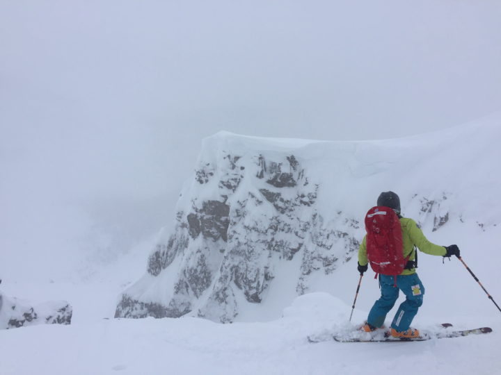
This late in the season & with the hot summer there was very little snow left. There was no overnight freeze. We were glad to have ice tools with us (and some of us were wishing for vertical front points).We climbed Mt Fay by the North Glacier/West Ridge route (45 in Jones guide).
![]()

We recommend this route only for adventurous types. The bergschrund is quite wide and on our trip was spanned by a (sketchy) snow bridge that consisted of a pile of tumbled snow blocks. Our leader opted to traverse the ice of the top half of the schrund rather than risk the snow, however this left us exposed to the snow overhead for a lengthy period & we got thoroughly soaked. We exited onto the upper snow slope which was quite soft. One short pitch on up with a single running picket to a snow anchor. The next pitch was protected with ice screws. There was a thin skim of snow on the ice at times which was a bit annoying: not enough for steps, but enough to frustrate sinking your picks. A third pitch got us to the ridge where we proceeded to the summit via the West Ridge route.

The West Ridge route is mostly a scramble. There is at least one low fifth step which is very exposed. It has excellent holds & can be short-roped from above. There is an additional short glacier section just before the summit. Two short rappels on bolted anchors take you past the steepest steps on the way down.

We returned by rapelling the snow gully west of route 45 described in Jones’ book, shorter with lower angle and very little bergschrund. The trail was not always obvious descending the ridge to the snow gully, but we ended up finding the best path on the northernmost ridgelet (the book calls is “promontory”). There were a couple of narrow, exposed steps on this descent.
We added a cordelette & quicklink to the existing slings around a large boulder at the top of the couloir or snow gully and rappelled off of it. With an intermittent abalokov, we reached the base of the snow gully with two 60m rapells. This snow gully also is the easiest & shortest access route to the West Ridge. At this time of year, even this one had thin snow & much exposed ice. Another party attempting it the following day with only single axes and turned back.

Another party reported excellent conditions on the Central Ice Bulge Direct (48 in Jones guide). There is a short steep section at the top (80º), but most of the 300m may be more like 45º.
Photos credit Wayne Hallstrom


0 Comments
Leave a reply
You must be logged in to post a comment.